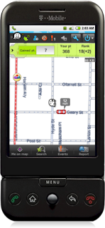
 Many people view this shift as a positive one, because they believe local people are bound to know their communities more intimately and are better equipped to deliver correct map information. There is also technology available now that gives the "everyman" the power to do what was once reserved for professionals and specialists. There are smart phones with GPS capabilities, such as the Waze driver generated mapping system. The Waze platform, pictured to the right, works on a smartphone and sends anonymous information back to you such as location and speed, and allows you to report on your travels. The way the system is set up, the more users that work with Waze, the more accurate the information will be.
Also, there are web tools, such as OpenStreetMap.org, Wikimapia, and now, Google Map Maker that are making it possible to create annotated maps that are open to the public for editing.
However, this new trend is not without its skeptics. While many people believe that the new publicly edited maps are just as accurate as traditional maps, the VP of global engineering at Tele Atlas insists that there is still a need for the due diligence and quality that professional map making firms provide. While they are integrating information from citizen cartographers into their maps, they believe that when it comes to emergency vehicle access or delivery routes, people need to be able to rely on professional map makers. He analogizes by saying that, Wikipedia, despite being a very interesting information source, is not a creditable source that historians will use to defend their theses. Furthermore, there is an inherent political characteristic of maps, especially in areas of land dispute. While professional map makers don't completely eliminate the politicization of maps, they can aim to treat certain areas with sensitivity. An open, anonymous system of editing is much more conducive to the creation of controversial maps.
In the end, it seems that the industry is currently being served by utilizing traditional, professionally gathered map data while still valuing the information that is contributed by local citizens.
